Pre-History
13,000-15,000 years ago: A series of huge floods caused by melting ice dams holding back Lake Missoula. The Lakeextended from Glacier National Park to the Idaho panhandle and held about 500 cubic miles of water. East of Ephrata, at Dry Falls, the water was 3.5miles wide, 400 ft deep and moved at 65 mph.
10,000 years ago: Methow Valley had glaciers up to a mile thick. At about that same time, there is evidence of human population in the Valley when the population of North America was estimated to have been in the 10’s of thousands or .013% of the current population.
European exploration of Western North America
1519: Hernan Cortes landed in present day Mexico with eleven ships, five hundred men, and the first thirteen horses in Western North America. Cortes formally claimed the land for the Spanish crown in 1521. In the wild, horse population grows exponentially at 15-20%/year. Starting with thirteen, in one hundred years, the population would be over one million.
1542: Spanish explorer, Juan Rodríguez Cabrillo, explored the West Coast of North America, reaching as far north as present-day Oregon.
1579: English explorer, Sir Francis Drake, sailed along the Pacific Coast, as far north as the Oregon Coast.
1607: Santa Fe (presently in New Mexico)foundedby the Spanish. In 1680, the Pueblo Indians revolted and pushed the Spanish out. The Spanish regained control 1692.
1741: Vitus Jonassen Bering, a Danish cartographer in Russian service, explored North America and the Alaskan Coast.
1778: British explorer, Captain James Cook, during his third voyage, explored the Pacific Northwest Coast, including parts of what is now Oregon.
1787: Charles William Barkley named the Straits of Juan de Fuca after the Greek navigator, who claimed to have explored the area in 1592 as part of a Spanish expedition.
1791: Francisco de Eliza named the San Juan Islands to honor his patron sponsor, Juan Vicente de Güemes Padilla Horcasitas y Aguayo, the 2nd Count of Revillagigedo.
1792: George Vancouver explored the West Coast of North America in search of a Northwest Passage. He named Puget Sound for his lieutenant Peter Puget.
1792: American sea captain, Robert Gray, discovered, navigated the entrance, traded for furs, and named the Columbia River, establishing a U.S. claim to the region.
1804-1806: The Lewis and Clark Expedition, commissioned by President Thomas Jefferson, explored, mapped, and established further U.S. claims to the Oregon Territory.
Development of the Pacific Northwest and Conflict with the Indigenous Peoples
1811: Fort Astoria was founded, at the mouth of the Columbia River, by John Jacob Astor’s Pacific Fur Company, the first American settlement west of the Rocky Mountains. That same year, Fort Okanogan was built at the confluence of the Columbia and Okanogan Rivers.
1813: During the War of 1812, the British claimed Fort Astoria, ending John Jacob Astor’s dream of a fur empire on the West Coast. The Northwest Fur Company followed by the Hudson Bay Company took over the fur trading business in the Columbia Basin.
1846-1848 American Mexican war. In the Treaty of Guadalupe Hidalgo, the United States claimed the states of California, Nevada, Utah, New Mexico and parts of Oklahoma, Kanas,Wyoming, and Colorado. The Texas border extended to the Rio Grande. This territory included the important population centers of San Francisco, Los Angeles, San Diego, Tucson, Santa Fe, and San Antonio.
1846: The Oregon Treaty, between the British and USA, settled the boundary dispute and joint occupation of the Pacific Northwest. The Hudson Bay Company was allowed continued usage of Fort Okanogan, which was mostly not staffed by 1850 and abandoned by 1860.
1847: On November 29, a small group of Cayuse Indians launched an assault on the Whitman Mission nearWalla Walla. This mission sheltered 74 people, most of whom were emigrants seeking a new life in the frontier. Thirteen people died, 49 were captured by the Cayuse, and the remaining 12 escaped. In response, the US Congress established federal control over the present-day states of Washington, Oregon, Idaho, and parts of Montana and Wyoming. The massacre became a pivotal moment in shaping the U.S. settlement of the Pacific Northwest.
1849: The start of a series of Gold Rush’s that shaped the west. These are major rushes, but there many smaller gold and silver rushes all of western states.
- Sacramento California 1849
- Fraser River Lillooet and Hope British Columbia 1850
- Colorado Gold fever 1858 “Pike’s Peak or Bust”
- Cariboo Mountains of British Columbia 1860
- Cripple Creek Co. 1890
- Klondike gold rush in Yukon district of Canada 1896
1853: Lieutenant George McClellan (who later commanded the Army of the Potomac in the Civil War) arrived at Fort Vancouver at the request of Washington Territorial Governor, Issac Stevens, to find a route through the Cascades for the railroad. This expedition alarmed the indigenous people as the white people were coming in larger numbers and demanding land.
1854: Ka Mi Akin, chief of the Yakima, and other important chiefs, organized a council of the Washington, Oregon, and Idaho indigenous tribes in the Grande Ronde Valley, in present day Oregon, where they agreed not to sell land or sign treaties with the whites.
1855: Governor Stevens arranged a great council to take place in Walla Walla. The Nez Perce were led by Chief Lawyer, who told Stevens that there was a plot by the Cayuses to kill the whites. Chief Lawyer signed a treaty favorable to the Nez Perce and also offered Stevens the protection of the Nez Perce against the Cayuses, negating the earlier agreement made in the Grande Ronde between the tribes.
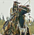
1855-1858 Indian Wars: Battles in the Indian Wars included many tribes (Yakama, Umatilla, Walla Walla, Snoqualmie) and large and small actions (Seattle, Walla Walla, Spokane Coeur d’Alene) and many smaller skirmishes and attacks on whites by Indians. The US Army was mobilized in to put down the revolt.
1858: The first Chinese worked on the Columbia, placer mining the sand bars. Over the following 25 years, the Chinese population on the river, from Rock Island, south of Wenatchee, to Similkameen River and Pend Oreille River in the north, grew to 1,500, about twice that of the white population. The Chinese played a key role in the development railroads, mines, fishery, farming, and business in the Western states. They were also among the first build ditches on tributaries of Columbia to feed water to the sauceboxes that separated sand for gold.
1869: First transcontinental completed when the Union Pacific Railroad and the Central Pacific Railroad connect in Utah.
1872: A large earthquake occurred, thought to have been centered near Chelan. The quake resulted in a landslide that blocked the Columbia River between Chelan and Entiat for a time and created a geyser near Beebe Springs.
1875: Methow Indians killed some Chinese on the Methow River followed by a general uprising. Indians continued to kill Chinese on the Columbia. South of Chelan, the Indians trapped as many as 300 Chinese on a ledge who were pushed or killed. The Chinese left the river for a time but returned and continued working the river until the Chinese Exclusion Act of 1882. 1879-1886: Chief Moses, of the Sinkiuse-Columbia Tribe, negotiated a large reservation, known as the Columbia or Moses Reservation, bordered on the West by Lake Chelan and the Cascade Crest, on the North by the Canadian border on the east by Okanogan River and on the south by the Columbia. The reservation included all the Methow Valley, Lake Chelan and the Western shore of Okanogan River. Hiram “Okanogan” Smith and other early settlers convinced the US government that there were valuable minerals along the Canadian border. In 1883, a 15-mile strip along the Canadian border was removed from the Columbia Reservation. By an act of Congress, the entire reservation was returned to the public domain in 1886